Effective maintenance of water utility assets is key to ensuring safety and water quality. Even the smallest ground movement near to, or at, water assets can have the biggest effects. Water asset managers need to be able to comprehensively monitor their pipelines and facilities to prevent bursts, failure, and interrupted services due to destructive ground and structure movements.
Influencing ground movement with manmade activities
As we build manmade water facilities and stores, like a
dam, we alter the natural landscape. To make a reservoir, processes that destruct the normal regime of underground and surface water are carried out. Combine these hydrotechnical construction operations with the soils used to form reservoirs, like silt and clay, and the potential for related ground movement is laid bare.
For these materials are highly susceptible to
erosion, shrinking, and swelling as water levels fluctuate, most prominently during seasonal change. For example, the water table can fall very low during dry periods; during wet seasons, the water table rises abruptly and a considerable part of the reservoir floor is under the influence of strong uplift. In turn, open cracks can occur and cause issues.
The effects of ground movement on water utilities
Back in the mid-1850s, Leeds selected the
Washburn Valley to supply its water. Three reservoirs were built around Fewston Village, with a total water storage capacity of an immense 8.2bn litres. Though such a volume aided the city’s increased demand for water, it also put huge pressures on the land.
Whilst puddled clay was selected to construct the reservoirs due to its watertight qualities, the assets themselves were built atop of shale, typically a flimsy foundation. As such, there were several landslides during the construction of the reservoirs, with Fewston residents experiencing large cracks running throughout the walls of their houses. In many cases, homes were so badly damaged that they became inhabitable.
Gravel and sand, on the other hand, shrink and swell at lesser rates but are more prone to getting washed away by water flow. So, for example, if one of the water pipes that makes up our complex water transportation network gets damaged and water leaks, the effects on the surrounding ground and infrastructure can be considerable. When water saturates or moves through the ground, it can cause foundations to give way, causing severe damage to buildings. Especially when such processes remain undetected for long periods!
How does water cause subsidence?
In many areas
groundwater is extracted from the earth to supply us with the water we need to survive. But as we extract water from the rocks below the ground, we disrupt the formation of rock. Seeing as water is a significant component of the ground’s structure, when we withdraw it, rock can become prone to falling in on itself. The resultant downwards ground movement, subsidence, is often experienced at
acquifiers.
It's important for asset managers of acquifiers to ensure that the rate at which water is being pumped out doesn’t exceed the rate at which groundwater is replenished for extended periods. Firstly, to ensure water doesn’t run out. Secondly, the more water pumped, the more compact the soil becomes. The acquifier reduces in size, meaning the amount of water it can hold decreases, too.
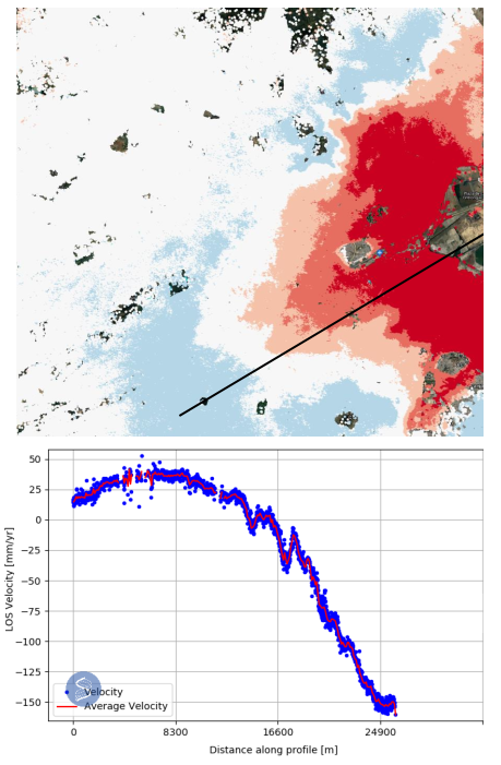
One of the most prominent examples of exploiting groundwater stores is in Mexico City. The
foundation of the Basilica of Our Lady of Guadalupe is sinking; the area has long extracted groundwater at this location, provoking both land subsidence and acquifier compaction. Buildings have been damaged, roads harmed, and general disruptions to water supply and waste drainage have been felt by the population.
The figure below demonstrates the ground movement velocities over part of Mexico City from 2016 to 2022 that SatSense's technology has been able to show!
Traditional monitoring VS InSAR
Water
assets are traditionally monitored using gauges and GPS receivers. However, installing these devices at every water site or store across a country, from dams to reservoirs to pipelines, is a costly and time-consuming exercise requiring ample human effort and travel. Not only this, but gauges rely on the ability to be located at specific points in order to accurately reflect the geophysical complexity of the landscape. Yet, where sites are
extremely remote or terrains are
challenging, monitoring can become intermittent by nature.
What’s more, GPS stations are prone to short timespans of records and data gaps. These tools also rely on in-person inspections to ensure they are working effectively. If it’s difficult to place a gauge at a certain site, it’s also going to be difficult for engineers to functionally access it.
As such, crucial data on the behaviour of the ground surrounding a water asset can be missed; even when it is detected, the delay from discovery to response can be costly, both in terms of time and consequence. Preventing, rather than reacting to, water-related crises should be a key focus for asset managers of water facilities. In order to achieve this, it’s essential to increase access to timely, accurate data that is continuously available.
How SatSense use InSAR
The
satellite technology, InSAR, is an effective complementary technique - in some cases,
the alternative to such traditional techniques. At SatSense, with data from the Sentinel-1 satellites, we use
InSAR processing to obtain millimetre-scale measurements of ground movement over huge areas, including the UK’s entire water pipeline network.
The data is retrieved
weekly, providing water utility companies and water facilities managers with insightful information on the state of the ground around their assets. Not only does this enable professionals to focus on the results of the data rather than repetitive monitoring tasks, it also promotes strategic decision making. Whether that be for maintenance, replacement, or future activities, options can be considered more informatively and standards upheld.
Measuring the risk of pipeline failure with InSAR
At the beginning of 2021, SatSense secured a study with the European Space Agency (ESA) Space Solutions. Using InSAR, we demonstrated the
correlation between our ground movement-derived metrics and pipe failure, working with a number of UK water utilities. We are now providing this service both in the UK and overseas, and plan to augment the service further with key partners.
If you would like to find out more about how our solution is helping asset managers to lessen environmental damage, reduce maintenance costs, and avoid leaks,
get in touch!