In the North of England, our client operates and manages reservoirs supplying drinking water to millions of customers. The client had concerns over suspected movement on a 160-year-old major reservoir embankment. By assessing our historical data record for past movement of the reservoir embankment and monitoring current movement, we assist in providing necessary information for management decisions of the reservoir embankment through quarterly reports. Ensuring embankment stability is a necessity to prevent the catastrophic effects of dam failure and to enable the full capacity to be utilised in preparation for times of drought. Climate change is increasing the likelihood and severity of extreme weather events which can dramatically alter water levels and change the forces exerted on the reservoir embankment thus requiring shorter measurement intervals achievable with our InSAR data.
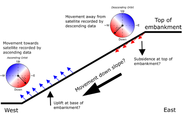
Schematic diagram interpretating key features of long-term movement observed by InSAR.
InSAR provides an alternative remote displacement monitoring technique that highlights where, when and how much the ground has moved for the area of interest. SatSense processes InSAR data in two viewing geometries to propose interpretations of the potential slip mechanics at our client’s reservoir embankment. Additionally, SatSense's InSAR product can be decomposed into vertical and horizontal movements to assess different sections of an observed reservoir embankment. The data density achievable demonstrated westwards movement of -5 to -15 mm/yr identifiable on solely the downstream embankment slope. This poses a significant risk to the reservoir embankments structural integrity. Focusing the location asset engineers should inspect to the downstream embankment slope has improved efficiency and minimised costs.
Our data interval of 6 days creates detailed time series to monitor ground movements and identify risks through a red, amber, green warning system across multi-annual, annual or sub-annual timespans. Data archives dating back to 2015 provide a robust record to assess changes in behaviour outside typical seasonal variations and alert asset managers without requiring costly site visits.