Using InSAR at desk study stage can help identify and assess movement risks across an entire site, hear how Ramage Young used our data to identify movement trends across their site.
The Project
SatSense provided InSAR data to assess if settlement was an ongoing issue at a disused quarry for the client, Ramage Young. The client was considering the suitability of the site for redevelopment purposes.
The Challenge
The main challenge was to assess if settlement had ceased at the site. If settlement was ongoing, this posed the question ‘what is the risk that differential settlement is occurring?’ Additionally, the site had water in the base of the quarry and was in a rural area, which can affect InSAR coverage.
The Solution
In the first phase of this project, rural processing was undertaken to increase coverage around the site. The rural processing provided additional coverage and 7 years of historical ground movement data for analysis. In addition to this, an interpretation report was provided that revealed that settlement was still ongoing, but the risk of differential settlement was low.
Subsequently, a quarterly monitoring regime was implemented, with data sent to the client to assess if the movement risk was ongoing and to help ascertain creep of the quarry base for design purposes.
LoS velocity map of Sentinel-1 ascending data, area used for time series analysis highlighted in blue.
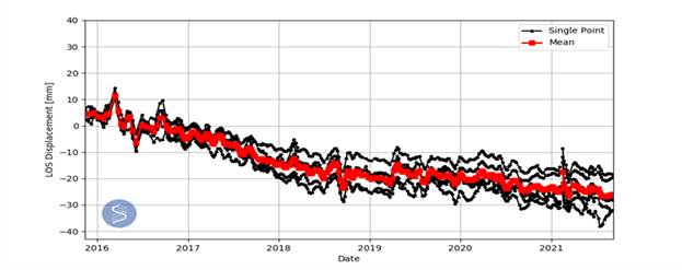
Time series of displacement.