Cyclic shrink/swell movements pose substantial geotechnical and structural challenges for managing transport infrastructure. In the South-East of England, the M25 has an abundance of London Clay earthworks prone to seasonal shrinking and swelling as changing weather conditions reduce or increase rainfall. SatSense's InSAR data can quantify the shrink/swell ground movements and produce bespoke shrink/swell risk indices to aid engineers. SatSense's primary dataset stretches back to 2015 to provide historic movement to identify if recent changes are unexpected or part of long-term trends.
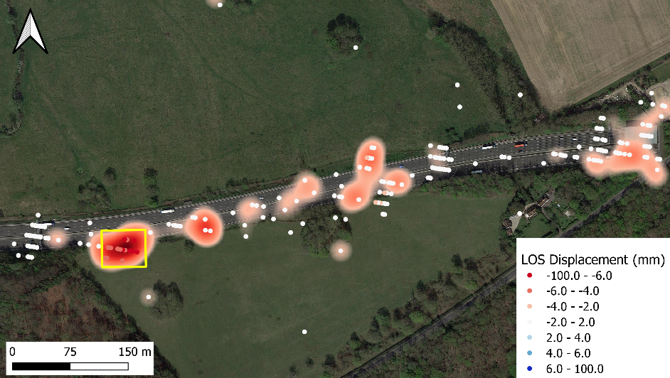
Map showing SatSense descending velocity vector data across the M25 and SatSense's bespoke shrink/swell risk indices overlaid on satellite imagery. Red points indicate movement away from the satellite implying subsidence and/or Westward movement. Areas denoted with a red glow are high risk shrink/swell regions where variation in displacement is sufficient to require monitoring.
Near Epping, our InSAR monitoring technique has identified a section of the M25 experiencing multi-year linear subsidence of -30 mm since 2015 with gradually increasing seasonal shrink/swell movements at approximately +/-15 mm for 2020. The precise quantification of shrink/swell and long-term trends improve the accuracy of factor of safety calculations for earthworks by our clients' engineers. Understanding which earthworks are at risk creates opportunities to take pre-emptive action rather than reactive and thus lower financial costs by avoiding regulatory fines or road closures. Historically, managing and improving strategic road networks involved costly site visits which posed potential health and safety risks. SatSense's InSAR monitoring is completely remote further reducing asset management costs.
As climate change is increasing the frequency and strength of extreme weather events leading to prolonged periods of drought or intense heavy rainfall, the risk of ground movement to infrastructure is growing. Severe drought or flooding can change the geotechnical properties of the soil exposing assets to movements outside their expected range. SatSense's data updates every 6 days such that the effects of recent weather events on assets can be measured and managed.
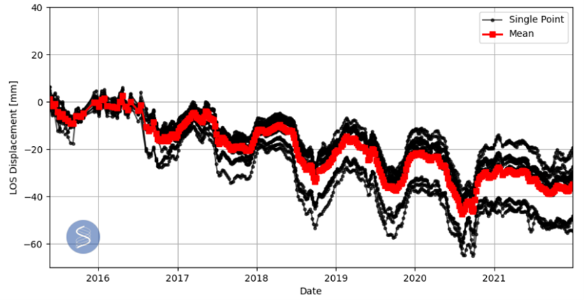
The time-series of the signal (indicated by the yellow box in the above figure) shows cyclic shrink/swell movement linked to clay soils as well as an overall downwards trend in displacement which is potentially beginning to stabilise. The cyclic signal was increasing in its range from 2015 with approximately +/-15 mm of movement in 20210 whilst the overall downward trend has led to 30 mm of displacement since 2015.