Getting ground movement direction out of our data

Wednesday, 08 July 2020

Using InSAR to measure horizontal and vertical movement in addition to the more commonly observed ‘line of sight’ geometry gives greater insight into behaviour of the ground.

Determining the direction, magnitude and rate of say horizontal movement allows, for example, any remedial work to be assessed, properly targeted and then monitored.

InSAR has clear advantages over traditional techniques in terms of convenient, regular, large scale ground movement measurements. It does have several peculiarities, one of which is that it only measures movement in the direction the radar is looking. Think of it as measuring something with a ruler, you're only measuring in the direction your ruler is in - not the direction perpendicular to it. Whereas you can of course place the ruler in any direction you want, the radar satellite is limited by its orbit, and the direction it looks in is the direction we get our measurements in.

Satellite beaming radar at a house while in ascending and descending line of sight

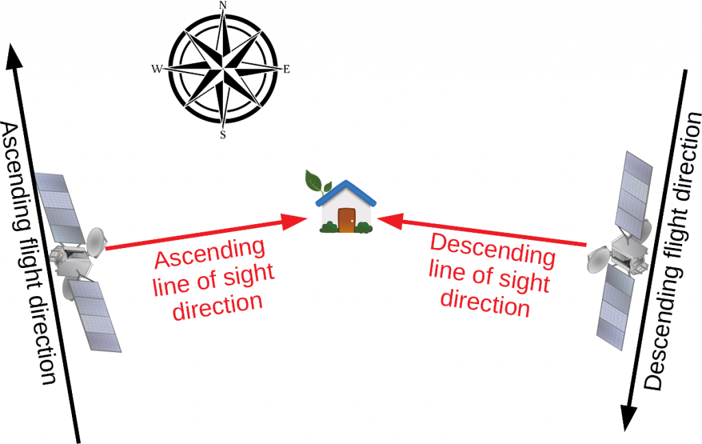
Schematic overview of the two InSAR viewing geometries available.


In practise this means that we have two independent look directions over any point (see above figure); One when the satellite flies approximately south to north, known as the ascending direction, and one when the satellite flies north to south, which is the descending direction. While flying in the ascending direction, the radar looks approximately to the east, and in the descending direction it approximately looks to the west. This allows us to separate horizontal and vertical motion.

Below is an example of SatSense ground movement rate ("velocity") data over the village of Ventnor on the Isle of Wight, which has a long history of landslips. The top image shows ascending data, the bottom image descending data, and indeed, significant movements are visible in the area. Interestingly though, the sign of the movements is opposite, mostly red (negative) for ascending, and mostly blue (positive) for descending. This tells us that the movement has a significant horizontal component.

Data from the ascending (top) and descending (bottom) satellite flight directions over the town of Ventnor, Isle of Wight. Red colours show movement away from the satellite. The data is showing opposite signs, which indicates a significant horizontal component

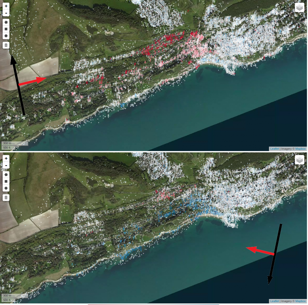
Above: Data from the ascending (top) and descending (bottom) satellite flight directions over the town of Ventnor, Isle of Wight. Red colours show movement away from the satellite. The data is showing opposite signs, which indicates a significant horizontal component.


Remember, the radar measures movement in the direction it is looking, and convention here is that movement away from the satellite is negative, making subsidence negative for both ascending and descending measurements, as the radar is looking down. For east-west movement, the radar is looking in opposite directions, and eastward movement would be away from the satellite for ascending overflights, and towards the satellite for descending ones. This is what we are seeing here, at least part of the movement is horizontal with a significant eastward component. This makes sense, as this means the cliff is moving seaward, as one would expect.

We can do better though by reprojecting the ascending and descending measurements into vertical and east movement components. In the below figure, this is done for the Ventnor area. It clearly shows eastward movement in the bottom panel. The vertical movements show downward movement at the top of the slope, and upward movement at the toe of the slip. The upward movement might be surprising, but this is caused by the moving landslide pushing against slower moving or stable ground, creating a bulge at the toe of the landslide.


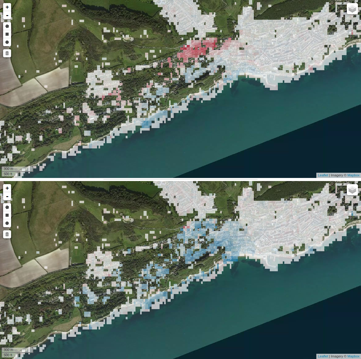
Above: Vertical (top) and East-West (bottom) decomposition of ground movement rates over the Ventnor area.


Reprojecting the measurements partly overcomes a main limitation of InSAR in terms of direction of movements. While here we have decomposed the movements in vertical and eastward, other assumptions can be made on the direction of the horizontal movements to get more appropriate results for particular area, e.g. by assuming the direction of movement to be downslope, or by using sparse GPS measurements as tie points. Vertical and east-west movements will be available as a data layer in our portal soon.


If you are looking to assess past ground movement, the impact of current works, or ongoing stability of infrastructure or property, get in touch to see if we can help - contact@satsense.com

 
SatSense Santa Tracker: Bringing Christmas Magic to Your DoorstepThursday, 05 December 2024 SatSense and Zonguldak Bülent Ecevit University Partner to Revolutionise Ground Movement Monitoring in TürkiyeTuesday, 23 July 2024 SatSense continues to support STEM students to drive innovationWednesday, 08 May 2024 Are UK water companies prepared for another record-breaking summer?Friday, 23 February 2024 Monitoring Rail Infrastructure Using InSARWednesday, 07 February 2024 Revolutionising Infrastructure Monitoring Using InSAR DataThursday, 01 February 2024 SatSense Gets Contract for the DRIPIN Demonstration ProjectWednesday, 24 January 2024 How can asset managers get the most out of InSAR? Monday, 21 August 2023 How can InSAR data be used in GIS software? Monday, 21 August 2023 7 Reasons Why Civil Engineers Should Be Using InSARMonday, 21 August 2023 SatSense and GNS Science Partner to Revolutionise Ground Movement Monitoring in New ZealandThursday, 20 July 2023 Do Onshore Wind Farms Come with Geotechnical Risk?Thursday, 22 September 2022 Our Water Networks Handled the Heat Last Time But What About the Next?Thursday, 11 August 2022 Analysing Bridge Movement Using Satellite DataFriday, 06 May 2022 To What Extent Can We Monitor Ageing Infrastructure?Tuesday, 03 May 2022 The Climate Change Challenge Facing Rail InfrastructureWednesday, 27 April 2022 Keeping Rail Asset Management on the Right Tracks with InSARWednesday, 06 April 2022 Remotely Monitoring Ground Movement for Water UtilitiesTuesday, 22 March 2022 A Damming DilemmaThursday, 10 March 2022 How Can Asset Managers Remotely Monitor Ground Movement?Tuesday, 08 March 2022 Using InSAR to Monitor Assets in Remote LocationsMonday, 28 February 2022 Overcoming Site Monitoring Challenges with InSARWednesday, 23 February 2022 Project Update: Using InSAR Data to Monitor Disused Coal Tips in WalesFriday, 28 January 2022 How Can Remote Technology Aid Tunnelling Engineers?Thursday, 13 January 2022 What Did 2021 Look Like for SatSense?Monday, 20 December 2021 Using InSAR to Monitor Rates of Coastal ErosionWednesday, 15 December 2021 Is it Time to Ground the Extraction of Groundwater?Tuesday, 30 November 2021 SatSense Appoints John McArthur as Chairman to Prepare for Further GrowthTuesday, 30 November 2021 Dam Important DataTuesday, 05 October 2021 Real Time Data Dashboards and the Future of Smart Asset MonitoringTuesday, 05 October 2021 LiDAR vs InSARMonday, 23 August 2021 SatShop Delivers Ground Movement Data at the Click of a ButtonThursday, 29 July 2021 The Light at the End of the TunnelWednesday, 21 July 2021 Join SatSense – we’re hiring!Thursday, 15 July 2021 Analysing movements of the UK’s railway with Network RailThursday, 24 June 2021 Using satellite data to reduce water leakageMonday, 19 April 2021 SatShop portal FAQ’s Friday, 09 April 2021 Satellite data at your fingertipsThursday, 04 March 2021 Avoiding mining disasters with InSAR dataTuesday, 26 January 2021 Using SatSense data to accelerate your geotechnical desk studyWednesday, 16 December 2020 Water treatment works expansionWednesday, 09 December 2020 Using InSAR data to magnify insight in previously unsighted industriesTuesday, 24 November 2020 Ways to improve InSAR data coverageWednesday, 07 October 2020 Automatically detecting movement of infrastructureFriday, 31 July 2020 Getting ground movement direction out of our dataWednesday, 08 July 2020 Creating the SatSense Data PortalTuesday, 07 July 2020 Detecting House Subsidence Using Satellites and InSARFriday, 05 June 2020 Risk indices for detecting ground movement issues using InSARMonday, 01 June 2020 Detecting sinkholes from spaceFriday, 08 May 2020 How SatSense stays ahead of the curveThursday, 07 May 2020 Matt reflects on joining SatSense and says a bit about himselfWednesday, 22 April 2020