Around the world in tunnelling advancements
Currently, some of the most impressive tunnelling projects are underway in a number of the world’s major cities. Though plans for HS2 have somewhat changed, the UK has just seen the opening of the Werrington Tunnel. Created by pushing an 11,000 tonne concrete curve under the East Coast Main Line, the tunnel has been heralded as one of the most enormous engineering accomplishments in the UK. Designed to take freight traffic off the passenger routes as part of a £1.2bn East Coast upgrade, the 56m long and 11.5m wide concrete structure was pushed into place underneath existing lines. Ground-breaking, almost literally!
Mainland Europe has the Brenner Base Tunnel under construction which, once complete, will be the longest underground rail link in the world. Crossing underneath the Alps between Innsbruck, Austria, and Franzensfeste, Italy, it will set new records in hard rock tunnelling. A modern Gripper TBM tunnelled its way through over 61m in just 24 hours!
Around the other side of the world and Sydney is extending its underground metro offering into its central business district, and beyond. From 2024, metro rail will have the capacity to serve a whopping 40k customers per hour thanks to metro trains in each direction every two minutes.
Whilst the above projects are incredibly exciting, they’re also incredibly challenging. The closer tunnelling projects come to city and civilian life, the higher the risk they pose. Disrupting formations in the countryside is one thing; beneath cities, another altogether. Engineers are balancing some very real risks of ground and building movements, as well as city-wide disruption. Extensive monitoring plans have never been more crucial, or more in demand.
Traditional tunnelling methods
Tunnelling has long married engineering experts with advancing technology to ensure construction projects of any shape or size can be pulled off as efficiently as possible. Traditionally, tunnel construction relies on specialist engineers travelling to proposed sites to take background ground movement, and building stability measurements to determine the suitability of an area for tunnelling. Once the project has been given the green light, they are then required to travel to, or be based on site, to continue to monitor such factors to ensure the project runs smoothly.
This way of working requires all equipment needed to take measurements to be installed across a wide variety of sites, buildings, and assets. Not only is this costly (in terms of the vast amount of apparatus required and the specialists needed to deploy it), but these instruments also all need calibrating, which can eat into valuable project time.
As the world becomes increasingly digitised, the tunnelling sector shouldn’t be left behind. Retrieving ground movement data doesn’t have to require specialists to literally be on the ground – it can be generated, retrieved, and analysed remotely, without compromising detail.
Tunnelling in a modern world
At SatSense, we take accurate, time-sensitive data generated by the radar satellites and turn this into a detailed picture of ground movement. Users are able to retrieve both current and historical data, allowing for the most comprehensive picture of past, current, and possible future trends.
For engineers, this massively reduces the need to be constantly travelling back and forth between the proposed or existing tunnelling site(s) and the office to generate, and then analyse, ground movement data. The status of suggested tunnelling projects can be determined at scale, frequently and quickly, saving precious time and money. The behaviour of the ground at the site can be measured and analysed faster, lessening the likelihood or tunnelling project delays.
What’s more, throughout the project and after its completion, InSAR data can continue to be streamed to relevant parties. This helps to ensure the continuous monitoring of the ground, with movement patterns relatively easily identified. Our data is updated every six days under normal conditions and can be accessed immediately, and we believe it will soon be an standard tool in the engineer’s toolkit.
Advancements to the Thames Tideway tunnel
Taking the Thames Tideway as an example, we can see the advances to the tunnel advancement mapped out in Figure 1.
Figure 1
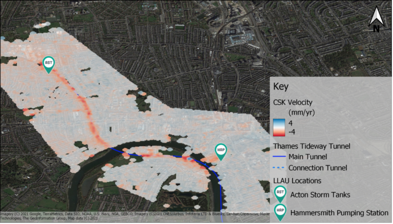
Tunnel advancement
When we select and analyse our InSAR map’s individual points, we reveal the time-series (Figure 2). This shows movement recorded when the tunnel boring machine passed through; from here, the user can identify the lateral extents of the construction works (Figure 3).
Figure 2
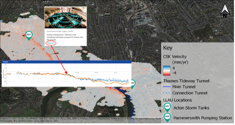
InSAR time-series
Figure 3
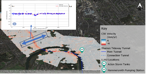
Lateral extents of construction works
InSAR allows for further interpretations of movement data, too; in this case, helping to pinpoint settlement troughs. During tunnelling projects, engineers can closely monitor how surrounding structures are responding to the different stages of works. Activities can be constantly assessed to ensure minimal disruption alongside maximum safety and effectiveness. Such knowledge is insightful for the shaping and improvement of future tunnelling projects.
Whilst ground movement data that results from tunnelling can be challenging to identify, it’s made far easier when traditional and contemporary methods are used in conjunction with one another. InSAR offers a greater point density at scale than traditional monitoring methods, allowing for a wider area of interest to be analysed. Moreover, urban areas already have the necessary reflectors in place in the form of buildings, helping SatSense to easily acquire the data needed to generate ground movement measurements.
InSAR is one of the most useful and technologically advanced tools that tunnelling projects are beginning to incorporate to increase their ability to best monitor ground and building movement. If you are interested in learning more, speak with one of our experts today!