Water treatment works expansion

Wednesday, 09 December 2020

Severn Trent water provides customers across the Midlands with 1.8 gigalitres of water per day, and recycles 1.4 gigalitres of water per day. As part of their plans to increase capacity at one of their waste-water treatment plants, they engaged AECOM to undertake an assessment for a potential expansion.

As with many locations across the UK, historical mining had a bearing on the site in question. Previously an open cast coal mine, the site needed to be assessed for settlement. Analysis is normally undertaken to confirm that most self-weight settlement has already occurred, and to predict future settlement to ensure it is within acceptable limits.

Options


A number of options were available to AECOM to undertake a study such as this. These included;

- Traditional measurement techniques such as the installation of extensometers, which would give some indication of movement for use in their designs. However, these would not be installed in time for the initial analysis, and at this time no historical data is available.

- A single download from our database of historical data from the last five years, for AECOM to analyse

- Our detailed report including expert interpretation of the historical data

- Ongoing monitoring, to identify any movement once building works have been completed

- Installation of our artificial reflectors for ongoing monitoring of exact known locations

Report Outcome


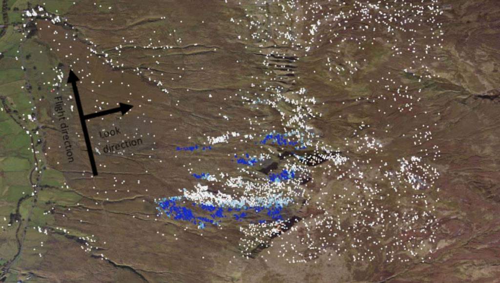
At SatSense, we have already processed data for the UK, which allows for rapid delivery and analysis of the data over the area of interest. Even at this country-wide scale, each measurement covers an area of approximately 4m x 14m providing a level of measurement coverage that was simply unaffordable until now.

The area in question is covered by four satellite tracks: two ascending orbits and two descending orbits. Each of the tracks has different degrees of coverage in both time and space. We extracted all the data we have available for the area of interest over the last five years and summarised the key findings for AECOM.


Ongoing monitoring would allow the identified movements to be verified and frequently checked to determine whether these pose a risk to the expansion plans. This monitoring could be performed using InSAR, alternative on-site survey techniques, or a combination of the two. InSAR monitoring of the fields could be improved by installing artificial reflectors but the level of coverage will likely increase once new structures have been built on the fields. The newly-built structures could then be monitored for any unexpected settlement and interventions could be put in place early.

The SatSense data allowed AECOM to assess the area for signs of movement. Based on the evidence collected, the types of footings required for building works could be determined, together with the requirements for further measurements.


If you need quick access to InSAR data, with expert analysis that can help you assess small to huge areas for development, expansion, or construction - get in touch with our team today.
SatSense Santa Tracker: Bringing Christmas Magic to Your DoorstepThursday, 05 December 2024 SatSense and Zonguldak Bülent Ecevit University Partner to Revolutionise Ground Movement Monitoring in TürkiyeTuesday, 23 July 2024 SatSense continues to support STEM students to drive innovationWednesday, 08 May 2024 Are UK water companies prepared for another record-breaking summer?Friday, 23 February 2024 Monitoring Rail Infrastructure Using InSARWednesday, 07 February 2024 Revolutionising Infrastructure Monitoring Using InSAR DataThursday, 01 February 2024 SatSense Gets Contract for the DRIPIN Demonstration ProjectWednesday, 24 January 2024 How can asset managers get the most out of InSAR? Monday, 21 August 2023 How can InSAR data be used in GIS software? Monday, 21 August 2023 7 Reasons Why Civil Engineers Should Be Using InSARMonday, 21 August 2023 SatSense and GNS Science Partner to Revolutionise Ground Movement Monitoring in New ZealandThursday, 20 July 2023 Do Onshore Wind Farms Come with Geotechnical Risk?Thursday, 22 September 2022 Our Water Networks Handled the Heat Last Time But What About the Next?Thursday, 11 August 2022 Analysing Bridge Movement Using Satellite DataFriday, 06 May 2022 To What Extent Can We Monitor Ageing Infrastructure?Tuesday, 03 May 2022 The Climate Change Challenge Facing Rail InfrastructureWednesday, 27 April 2022 Keeping Rail Asset Management on the Right Tracks with InSARWednesday, 06 April 2022 Remotely Monitoring Ground Movement for Water UtilitiesTuesday, 22 March 2022 A Damming DilemmaThursday, 10 March 2022 How Can Asset Managers Remotely Monitor Ground Movement?Tuesday, 08 March 2022 Using InSAR to Monitor Assets in Remote LocationsMonday, 28 February 2022 Overcoming Site Monitoring Challenges with InSARWednesday, 23 February 2022 Project Update: Using InSAR Data to Monitor Disused Coal Tips in WalesFriday, 28 January 2022 How Can Remote Technology Aid Tunnelling Engineers?Thursday, 13 January 2022 What Did 2021 Look Like for SatSense?Monday, 20 December 2021 Using InSAR to Monitor Rates of Coastal ErosionWednesday, 15 December 2021 Is it Time to Ground the Extraction of Groundwater?Tuesday, 30 November 2021 SatSense Appoints John McArthur as Chairman to Prepare for Further GrowthTuesday, 30 November 2021 Dam Important DataTuesday, 05 October 2021 Real Time Data Dashboards and the Future of Smart Asset MonitoringTuesday, 05 October 2021 LiDAR vs InSARMonday, 23 August 2021 SatShop Delivers Ground Movement Data at the Click of a ButtonThursday, 29 July 2021 The Light at the End of the TunnelWednesday, 21 July 2021 Join SatSense – we’re hiring!Thursday, 15 July 2021 Analysing movements of the UK’s railway with Network RailThursday, 24 June 2021 Using satellite data to reduce water leakageMonday, 19 April 2021 SatShop portal FAQ’s Friday, 09 April 2021 Satellite data at your fingertipsThursday, 04 March 2021 Avoiding mining disasters with InSAR dataTuesday, 26 January 2021 Using SatSense data to accelerate your geotechnical desk studyWednesday, 16 December 2020 Water treatment works expansionWednesday, 09 December 2020 Using InSAR data to magnify insight in previously unsighted industriesTuesday, 24 November 2020 Ways to improve InSAR data coverageWednesday, 07 October 2020 Automatically detecting movement of infrastructureFriday, 31 July 2020 Getting ground movement direction out of our dataWednesday, 08 July 2020 Creating the SatSense Data PortalTuesday, 07 July 2020 Detecting House Subsidence Using Satellites and InSARFriday, 05 June 2020 Risk indices for detecting ground movement issues using InSARMonday, 01 June 2020 Detecting sinkholes from spaceFriday, 08 May 2020 How SatSense stays ahead of the curveThursday, 07 May 2020 Matt reflects on joining SatSense and says a bit about himselfWednesday, 22 April 2020