Core challenges asset managers face in relation to ground movement
Asset managers face varying challenges depending on project scope and the assets they monitor. For instance, ageing infrastructure already poses a higher risk of potential failures. Add to this the strain of population growth and urbanisation, and older assets can quickly fall victim to changes in the ground. As such, frequent monitoring through site visits is necessary. Whilst such activities are an integral part of the asset team’s role, they can exhaust resources both in terms of time and cost, especially in cases when several engineers are required to visit the same asset multiple times. Not only that, but the challenge of identifying millimetric ground movement in the field is a difficult task to spot by eye alone!
What’s more, where assets are located remotely or among challenging terrain, more traditional methods of monitoring ground movement (like tiltmeters and inclinometers) can be complicated to install. In addition to the logistical challenges of unforgiving terrain, field instrumentation also requires calibration. This takes time, widening the window for unaccounted ground movements.
So, how can ground movement be better monitored?
The physical sensors traditionally used to detect ground movement tend only to be installed on assets where hazards have already been identified. In some cases, it is impossible to monitor every asset, every week, meaning some hazards may go unnoticed for some time. This delay in identifying ground movement issues across the entire network can pose safety risks and lead to more expensive repairs being required. All of these challenges pose the question: how can millimetric movement be detected across multiple kilometres of network safely and cost-effectively?
Remote satellite observation technology is increasingly being used to comprehensively monitor and visualise ground movements across an entire asset’s footprint. Monitoring data is updated every week and has mm/yr accuracy, meaning asset managers can now use a tool that remotely keeps an eye on their assets every week. Furthermore, visualising satellite data using coloured points and heatmaps allows asset owners to quickly see where their team needs to visit to check for worrisome signs of movement.
[caption id="attachment_1071" align="aligncenter" width="815"]
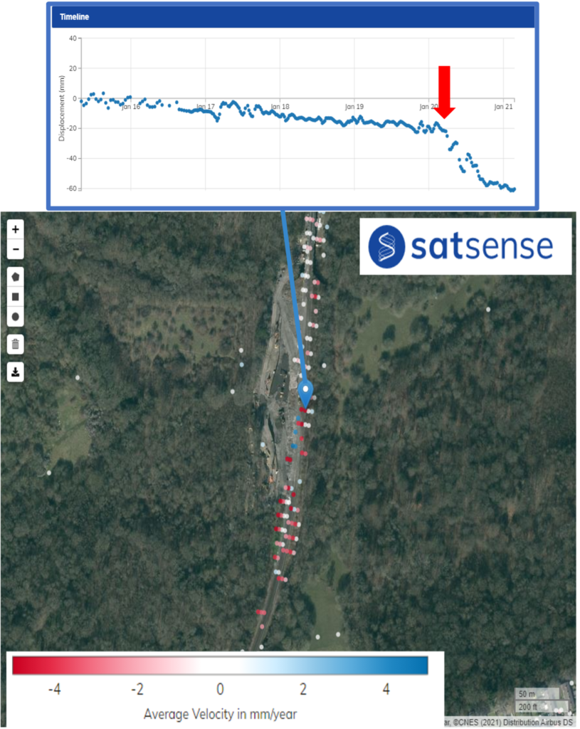 Figure 1[/caption]
Using visual tools, such as coloured velocity points, allows areas of significant movement to be seen. Asset managers and their teams can then identify and direct their resources to areas of concern. In Figure 1, a cluster of red velocity points stand out among the white velocity points, pinpointing locations for further investigation. When clicking on the velocity points, the historic ground movement is displayed. For the point above, continual downwards displacement of 20mm was recorded between 2017 and 2020, before a sudden increase of around 40mm in 6 months during 2020, which corresponded with a landslip-type failure at this location.
How does InSAR detect ground movement?
Satellites orbit Earth continuously, providing SatSense with two data acquisitions every twelve days. This allows for any changes in ground movement to be identified early and necessary interventions put in place promptly. As the satellite orbits, it emits an electromagnetic beam that reaches the Earth’s surface and is reflected back to the satellite’s sensor (Figure 2). Processing of this data allows a displacement measurement to be obtained; as the satellite is continually orbiting, an understanding of how the ground surface is changing over time is realised.
Satellite data is a complementary tool that helps asset managers identify areas to inspect. It doesn’t strictly replace physical inspections, but it does help to reduce their frequency. The technicalities of InSAR involve using satellite data to identify the changes in the altitude of a land surface over time. Key locations where this technology can be used include utility, road and rail networks, as well as for water asset management, to name only a few!
[caption id="attachment_1072" align="aligncenter" width="1024"]
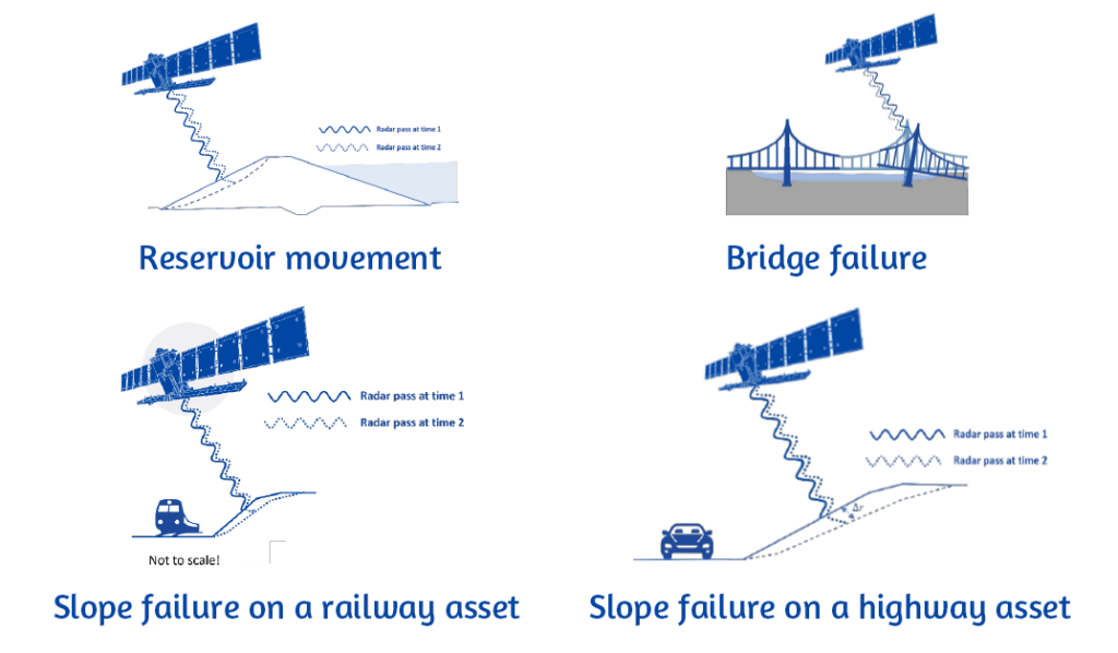 Figure 2: Example use-cases for InSAR[/caption]
The remote, non-intrusive, and weekly frequency of this technique complements existing monitoring techniques while providing an eye on entire asset networks, no matter the weather conditions. As such, the accessibility and opportunity to have full visibility across an entire asset’s ground movement activities allows critical assets to be more effectively monitored and maintained. Additionally, using early warning alert systems and risk metrics developed in-house at SatSense could help in identifying worrisome movements that could compromise safety and the lifespan of an asset.
Are you an asset manager looking to better monitor ground or structure movement? Get in touch to find out how we can help!